基于WebGIS的应急避难场地展示系统开发毕业论文
2020-04-15 20:22:35
摘 要
应急避难场地可以在发生突发灾害时给人们提供一个减少伤害、相对安全的环境,其相关信息的普及对于我国这样一个地域广、人口多且多灾多害的国家至关重要。近年来,随着计算机技术的发展GIS在处理数据、模型分析等方面有了更大的提高,使用WebGIS技术开发应急避难场地展示系统逐渐成为受开发者欢迎的开发方式。
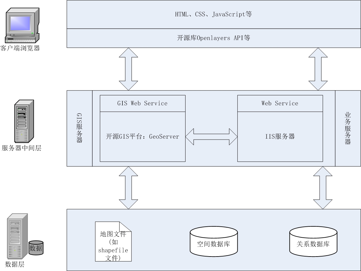
本文介绍了使用主流的开源WebGIS平台GeoServer、Openlayers以及用于存储空间数据的PostgreSQL和PostGIS来开发应急避难场地展示系统。该系统以江苏省应急避难场地数据为基础,主要使用HTML和CSS对前台页面进行设计,使用JavaScript编写前台的事件处理函数,后台代码使用C#语言编写。本系统的开发使用Openlayers中的类实现对地图进行加载、服务数据加载、服务数据的管理、叠加图层、添加标注等功能,主要解决了在突发灾害前后应急避难场所信息的展示问题。
本文的现实意义的主要如下:
(1)加大对应急避难场地信息的普及,设计友好界面,利用GIS可视化数据为人们展示详细应急避难场地的信息,方便人们在发生突发灾害时快速前往应急避难场地避难。
(2)使用开源WebGIS平台搭建应急避难场地展示系统,很大程度上降低成本,并且数据共享性高。
(3)详细描述了该系统的设计和实现,为参阅者提供可靠的实现方法。
关键词:WebGIS;应急避难场地;开源;GeoServer;Openlayers
Abstract
Emergency Shelter can provide a relatively safe place with people and reduce injury when a disaster burst out unexpectedly,and for our country where area is so large and the number of people is large too with mang disaters happening frequently , it is an important thing to popularize the information of Emergency Shelters.In recent years,with the development of technique of computer,GIS has much improvement in processing data and model analyzing and so on.To use the technique of WebGIS to develop the Emergency Shelter Presentation System is more and more popular for most developers.
This paper introduces the use of the prevailing OpenSource platform of WebGIS including GeoServer and Openlayers,and PostgreSQL and PostGIS which aims for storing spatial data to develop Emergency Shelter Presentation System.The system is based on data of emergency shelter of Jiangsu Province,mainly using HTML and CSS to design the front page ,using JavaScript language to write event handler function for front page. In the background ,the system uses C# language to write code.The development of this system is to use the classes of Openlayers to realize functions such as loading map or service data,management of service data,overlay of layer,adding marker and so on.It can solve the main problem of presentation of shelters’ information before or after disasters.
The realistic meanings of this paper can be concluded in the following:
(1)enhance the promotion of information of emergency shelters,design friendly user interface and make use of visualizing data of GIS to show details of emergency shelters.It is convenient for people to move to these shelters quickly when a disaster happens.
(2)use OpenSource WebGIS platform to build the system,to a large extent it reduce the costs and the data is shared.
(3)describe the design and design in detail, provide with readers reliable methods to realize the system.
Keywords:WebGIS; Emergency Shelter;OpenSource;GeoServer;Openlayers
目录
摘要 I
Abstract II
目录 III
第一章 绪论 1
1.1 研究背景 1
1.2 研究现状 2
1.3 研究目的及意义 2
1.4 论文组织结构 3
第二章 开源WebGIS及相关技术 4
2.1 开源WebGIS 4
2.1.1 常见开源WebGIS项目 4
2.1.2 OGC及相关规范 5
2.2 GeoServer 5
2.2.1 GeoServer介绍 5
2.2.2 GeoServer安装部署 5
2.3 Openlayers 6
2.3.1 Openlayers介绍 6
2.3.2 Openlayers类库包 7
2.4 Web前端开发技术 7
2.4.1 HTML5 7
2.4.2 CSS3 8
2.4.3 JavaScript amp;amp; JQuery 8
2.4.4 Ajax技术 8
第三章 应急避难场地展示系统设计 10
3.1 需求分析 10
3.1.1 系统总体需求分析 10
3.1.2 主要功能需求分析 10
3.2 系统总体设计 11
3.2.1 技术路线的选择 11
3.2.2 关键技术 12
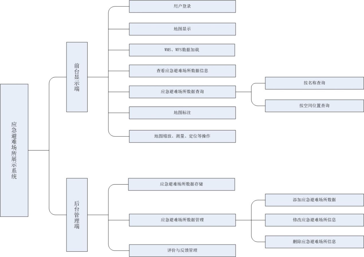
3.2.3 主要功能模块 12
3.3 系统主要功能设计 13
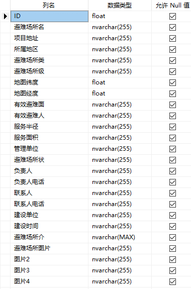
3.4 系统数据库设计 14
第四章 空间数据的存储和面向服务发开 16
4.1 主流的开放数据格式 16
4.1.1 KML 16
4.1.2 GeoJSON 16
4.2 数据格式的转换 16
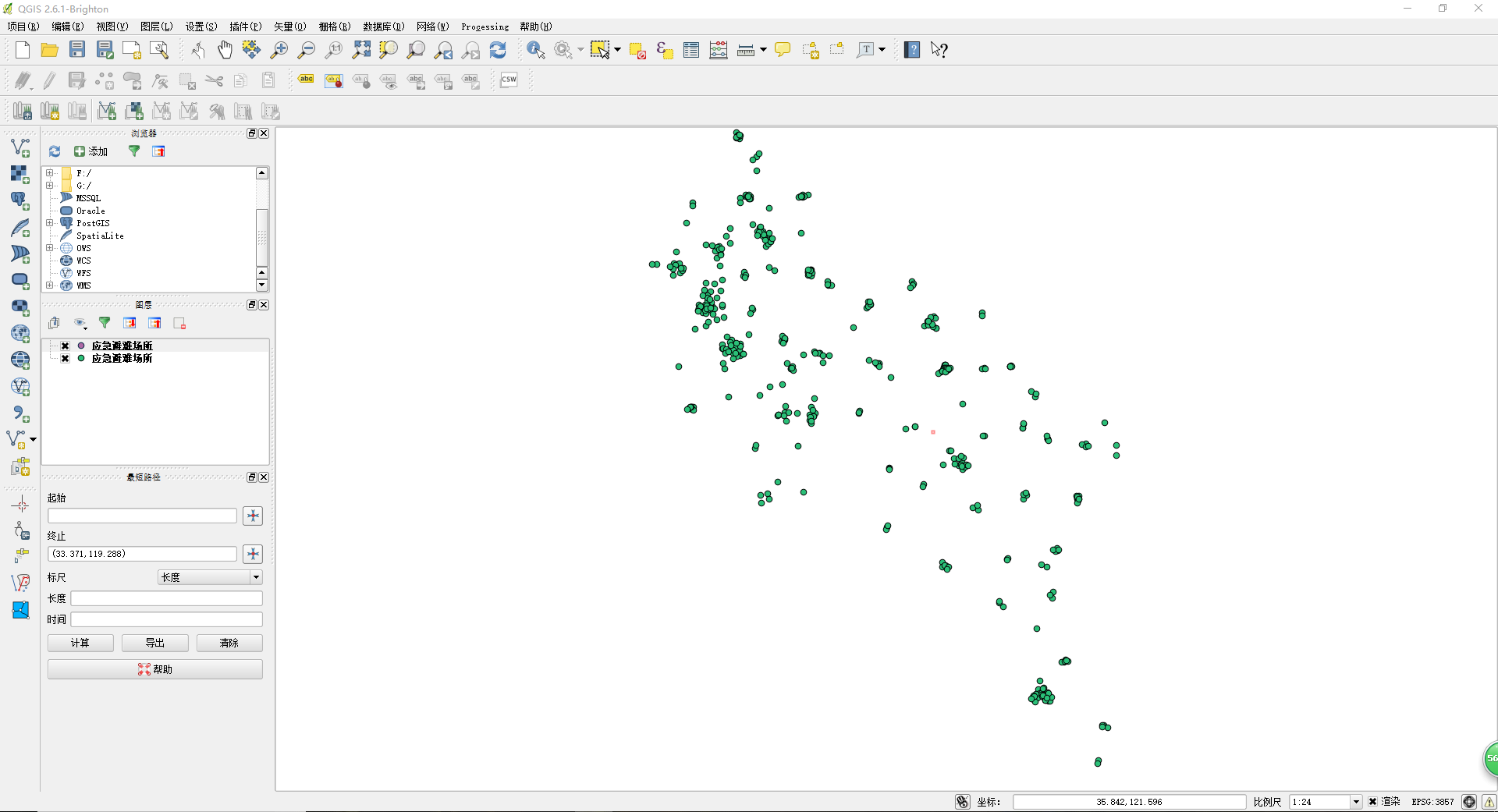
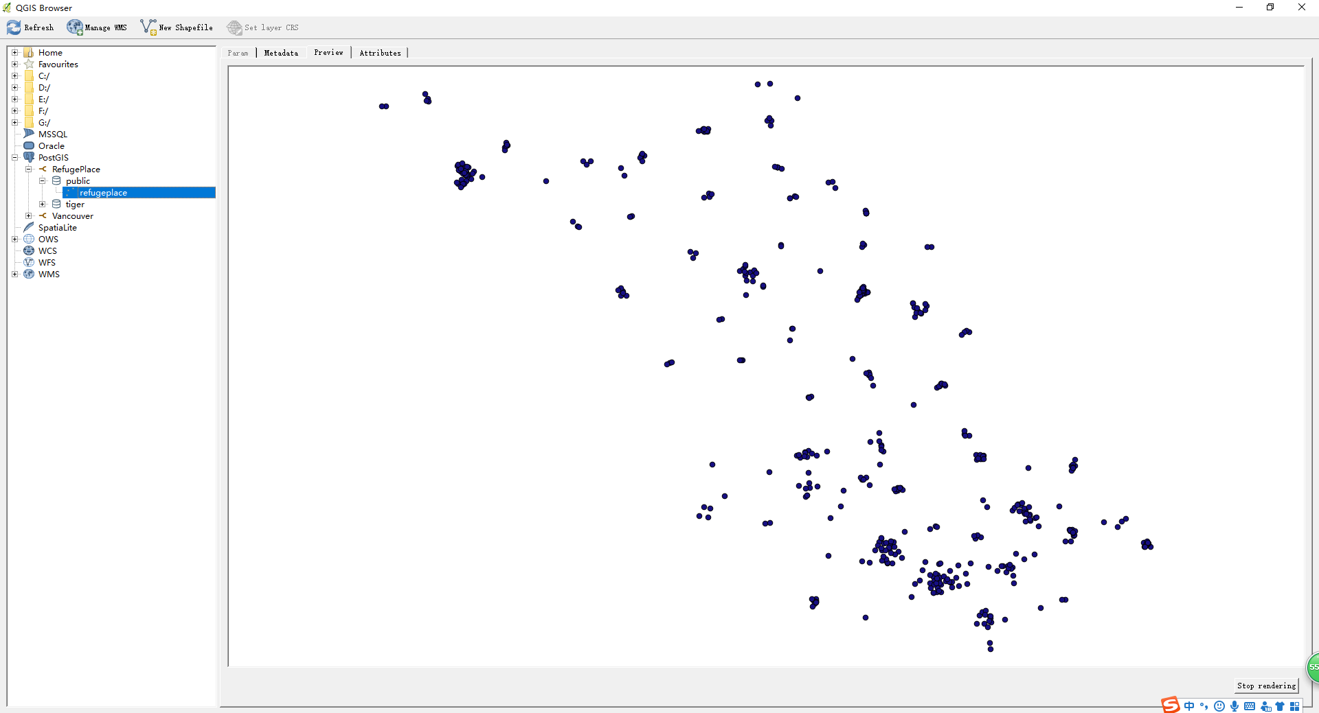
4.2.1 QGIS 介绍及安装 16
4.2.2 使用QGIS转换成.shp格式的文件 17
4.3 PostgreSQL与PostGIS 17
4.4 面向服务的开发方式 18
4.4.1 WMS 18
4.4.2 WFS 18
第五章 应急避难场地展示系统实现 20
5.1 数据库的建立 20
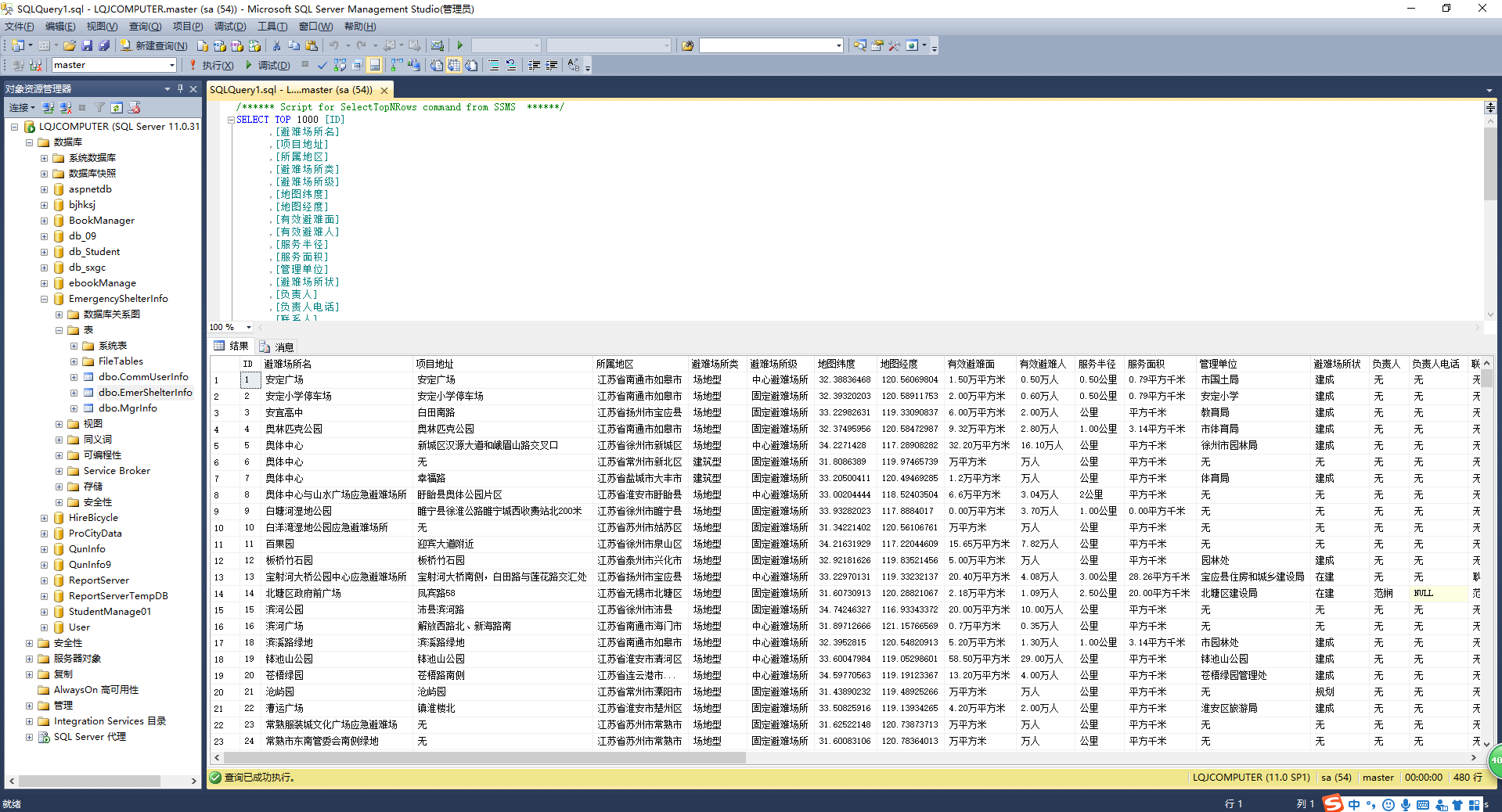
5.1.1 数据存入SQL Server 20
5.1.2 用PostgreSQL PostGIS存储 20
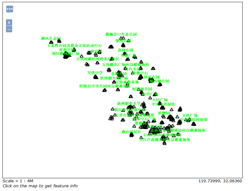
5.1.3 数据发布 21
5.2 系统功能实现及成果展示 23
5.3.1 用户登录模块实现 23
5.3.2 地图显示模块实现 25
5.3.3 WMS、WFS数据加载模块实现 26
5.3.4 地理数据CRUD模块实现 29
5.3.5 地图查询模块实现 31
5.3.6 地理标注模块实现 33
5.3.7 其他基础功能实现 34
5.3.8 用户反馈模块实现 35
5.3.7 界面编排 36
第六章 总结与展望 38
总结 38
展望 38
参考文献 39
致谢 41
第一章 绪论
1.1 研究背景
我国是一个地域广、人口多且物质丰富的国家,但经常发生自然灾害,若不加以防治,损失会相当严重。应急避难场地建设是防震减灾工作的重要组成部分,该项工作从无到有、再到在全国范围内具有一定规模的覆盖面,大大地推进了我国防震减灾事业的发展[1]。近年来,政府进一步扩展避难场地的建设,且重视程度越来越高,应急避难场地的信息的普及也成为了很重要的工作。但是由于应急避难场地信息化建设缓慢,避难场所信息的发布与宣传手段过于单一,普及面窄,使得绝大多数周边居民都不清楚避难场所的位置、场所的详细信息、到达场所的最近路径和场所功能等公共服务信息,这将大大降低减灾效果[2]。因此,若有一个有效的向公众展示应急避难场地信息的平台,减灾效果会大大加强。
地理信息系统(GIS,Geographic Information System)是一门综合性学科,结合地理学与地图学以及遥感和计算机科学,已经广泛的应用在不同的领域,是用于输入、存储、查询、分析和显示地理数据的计算机系统[3]。WebGIS技术是随着GIS与Web技术的结合而产生,它已成为GIS发展的主要趋势之一,且一定会融入到人们生活的各个方面。WebGIS是利用Internet技术来扩展和完善GIS的一项新技术,其核心是在GIS中嵌入HTTP标准的应用体系,实现Internet环境下的空间信息管理和发布[4]。
以上是毕业论文大纲或资料介绍,该课题完整毕业论文、开题报告、任务书、程序设计、图纸设计等资料请添加微信获取,微信号:bysjorg。
相关图片展示: