地铁二号线元通站-雨润大街站地铁保护区监测方案设计语实践毕业论文
2020-06-20 19:11:00
摘 要
近些年来,社会经济不断地发展,道路交通不断地拓展,激发着新型交通方式的发展,地铁便是其发展中的一个重要产物。又因为人口的爆炸性的增长,给交通带来了巨大的压力,地铁的出现,很大程度上缓解了各大城市交通压力。但地铁的建设需要一个良好的周边环境,城市中的高楼大厦的建设中基坑的挖掘,对于地铁隧道的建设是一个巨大的威胁。
其中那些超大基坑建筑,对其隧道的威胁尤其重大,关系到隧道变形的问题。所以,想要地铁在运营中更加的安全,减少或避免因地铁事故给人们带来的生命安全的威胁和财务经济损失,必须要制定一个合理的保护区监测方案。
本设计通过结合地铁二号线元通站-雨润大街站施工及周边的具体情况,论述以下几个方面的内容:
(1)文章首先论述了地铁保护区的内容、目的和意义,接着介绍了地铁保护区的发展历程和现阶段研究的状况,然后对地铁二号线元通站-雨润大街站的工程概况做了大概说明。
(2)在信息获取上,采用自动化监测和人工监测相结合的办法,其中在自动化监测系统选择上选用GeoMos系统。系统可以根据工程的具体需要,对其可以进行二次开发,并采用莱卡TM30自动全站仪,精度完全能够保证隧道变形监测的精度要求。
(3)对地铁二号线元通-雨润大街站监测结果和数据进行具体的处理和分析,在数据入库前,先对数据进行预处理,要保证数据的准确性。之后对数据进行粗差检查,对于存在了明显的错误要及时的删除。
(4)最后结合岩土方面理论知识、支护结构和监测数据,综合有效的分析变形原因,及时的采取应对措施,保证地铁工程的安全运行。
关键词:地铁保护区 变形监测 水平位移 沉降 收敛变形
Design and Practice of Monitoring Scheme for Subway Protection Area of Yuantong Street Station of Metro Line
Abstract
In recent years, the social and economic development, road traffic continue to be expanded, to stimulate the development of new modes of transport, the subway is an important product. And because of the explosive growth of the population, which brings great pressure on the traffic, the emergence of the subway, largely alleviates the major city traffic pressure. But the construction of the subway needs a good surrounding environment. Pitting excavation of the construction of high-rise buildings in the city, which is a big threat on the constraction of the subway.
Among them, those large foundation pit construction, which has an especially large threat on tunnels, which is related to the problem of tunnel deformation. Therefore, it is necessary to develop a reasonable protected area monitoring program if you want the subway to be more safe in operation, reducing or avoiding the threat of life safety caused by the subway accident and the financial and economic loss.
The design of the subway through the construction of the second line and the surrounding specific circumstances, discuss the following aspects:
(1)The article is first discussed on the contents, purpose and significance of the subway protected area, and then introduced the development course of the subway protected area and the current research situation. Then, it is summarized the project profile of Yuantong Station - Yurun Street.
(2)In the information acquisition, the use of automated monitoring and manual monitoring,the two metheods are combined, in which the choice of automated monitoring system selection is GeoMos system .The system can be based on the specific needs of the project, it can be secondary development, and the use of Lycra TM30 automatic total station, the accuracy of the tunnel is to be ensured by the accuracy of deformation monitoring requirements.
(3)To the Metro Line 2 Yuan Tong - Yurun Street Station monitoring results and data for specific processing and analysis, data storage, the first data pre-processing, to ensure the accuracy of the data. After the gross inspection of the data, there are obvious errors to the timely removal.
(4) Finally, combined with theoretical knowledge of rock and soil, supporting structure and monitoring data, comprehensive and effective analysis of the causes of deformation, timely response measures to ensure the safe operation of subway projects.
Keywords: Subway reserves;Deformation monitoring; Horizontal displacement; Settlement;Convergence deformation
目 录
摘要 I
Abstract II
第一章 绪论 1
1.1地铁保护区监测内容、目的与意义 1
1.2地铁保护区监测的发展历程和现状 1
1.3地铁二号线元通站-雨润大街站工程概况 2
1.4方案设计思路 3
1.4.1研究内容 3
1.4.2监测方法 3
第二章 地铁保护区监测精度的要求 4
2.1监测精度要求 4
2.2监测等级确定 5
2.3变形监测注意事项 5
2.4监测频率和预警值和报警值 6
2.4.1监测频率 6
2.4.2预警值及报警值 6
第三章 地铁保护区监测内容与方法 8
3.1点的布设要求 8
3.2水平位移监测 8
3.2.1水平位移监测点的布设 8
3.3沉降监测 9
3.3.1沉降监测点的布设 9
3.3.2沉降监测的方法 10
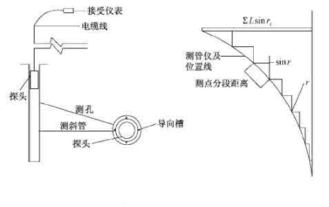
3.4深层水平位移监测 11
3.4.1测斜管的基本原理与埋设 11
3.4.2斜测仪施工中的问题及处理措施 12
3.5支护结构的内力监测 12
3.6地下水位监测 13
3.7裂缝监测 13
3.8人工监测 13
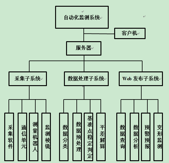
3.9自动化监测 14
3.9.1监测方法 14
3.9.2自动化监测系统与设备 15
第四章 南京地铁二号线元通-雨润大街站监测数据处理与分析 16
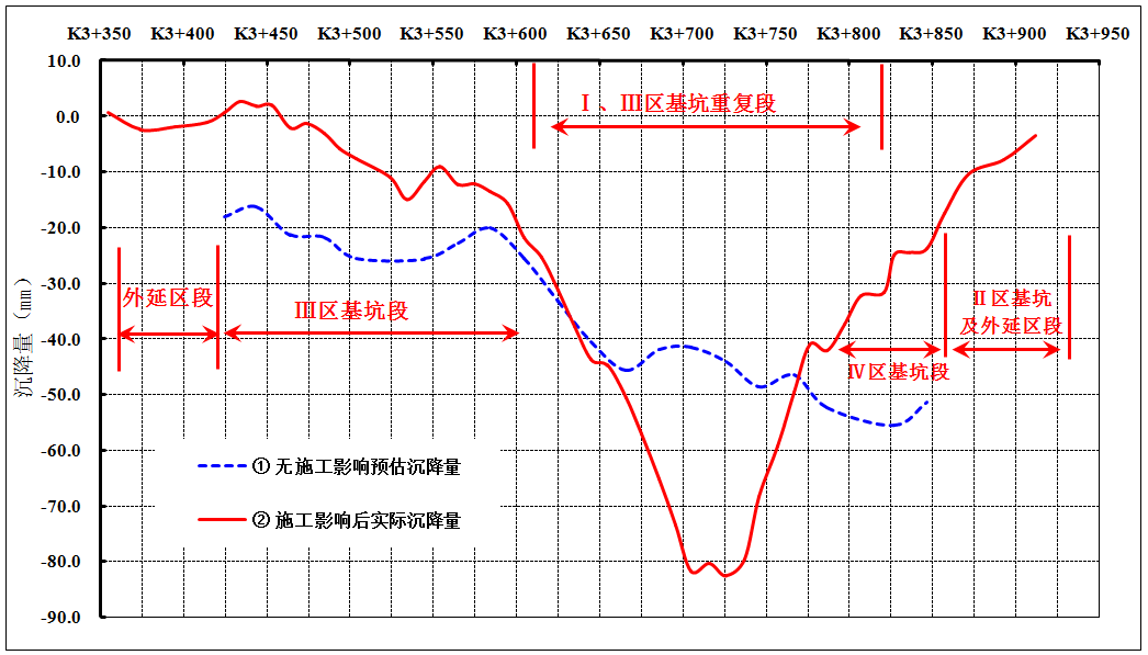
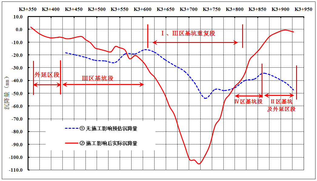
4.1数据分析处理步骤 16
4.2注浆数据分析 16
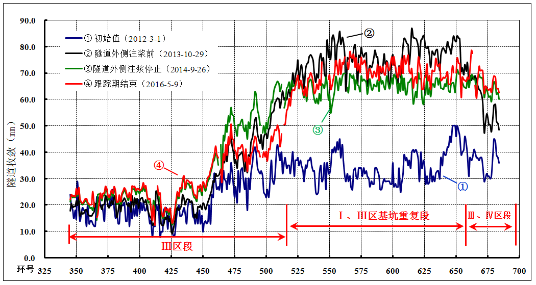
4.2.1垂直位移 16
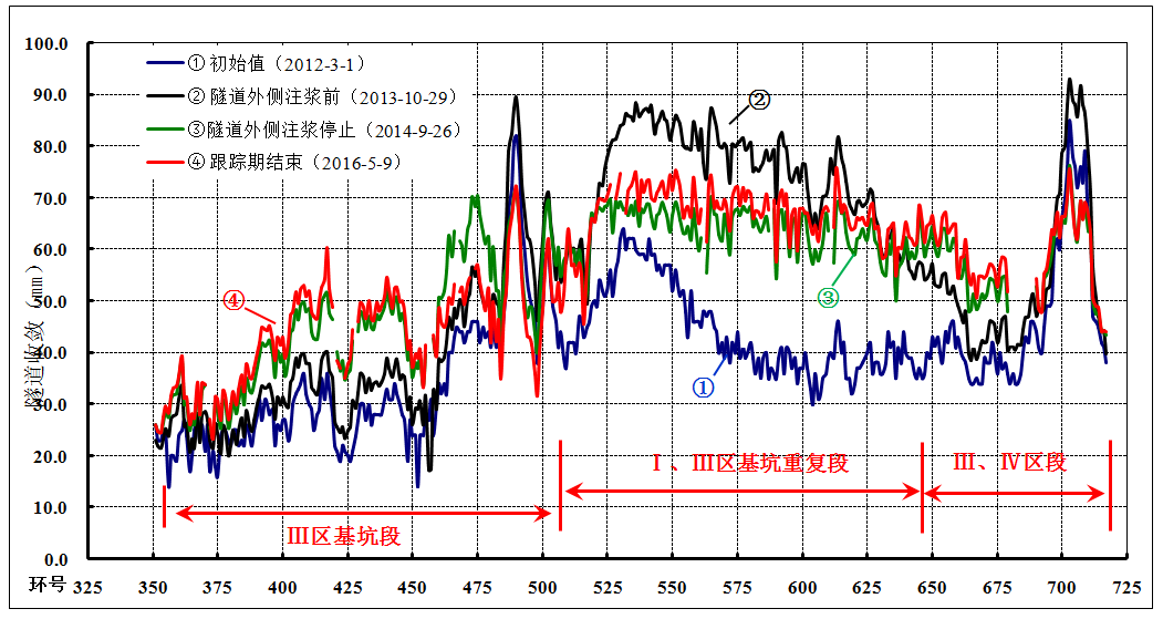
4.2.2隧道水平收敛 18
4.2.3沉降 19
4.3总结 19
第五章 结语与展望 20
参考文献 21
致谢 23
第一章 绪论
1.1地铁保护区监测内容、目的与意义
监测的内容包括:水平位移监测、垂直位移(沉降)监测、收敛变形监测[1]。地质表层和土地深处的各种変形要素全都是变形监测施工时进行测量的主要项目[2]。
在基坑坑开挖施工的过程中,地基内每个点上受到的力包括土体自身的重力,另外还要加上建成的建筑物的重力,而建筑物周边的土地,只是受到了土地自身的重力,这样,两边所承受的力的大小不相同,受到挤压的程度也就不同,从而使土地形状发生的改变量不同,表现出来的实际情况也会不同,这样就会让施工存在安全隐患。因此在基坑和结构施工过程中,制定出一个详细的监测方案,在监测过程中,能够对数据采取恰当的方法进行解析,对土地的形状的改变能够及时的发现,才可以保障施工人员施工时的安全和施工成果的安全与稳定[3]。
1.2地铁保护区监测的发展历程和现状
早些年前至今,城市的基坑工程发展迅速,特别是在现在,城市的复杂化,深基坑工程数量的增大,对地铁的建设加大了难度[4]。正是因为如此,地铁建设技术也在不断地发展。
随着交通工具的巨大变化表现出城市在不断变迁发展,而城市中是否建设有地铁,则侧面表现出了其城市的繁华。随着时间的推移,地铁将会遍布各个城市。因此,今后地铁的需求是巨大的。20世纪90年代初,国内大型的深基坑工程项目只有极少数的城市才出现,周围也没有相邻的建筑物。从19世纪90年代后期发展到现在,高层建筑如春笋般涌现。现如今的城市中,许多高层建筑,考虑到经济因素,会把基坑挖的很深,在地下也会建造建筑,所以基坑的深度相比较以前会深很多,最大的会有30m的深度。在一些大中型的城市中,如北京,上海,长沙[5],南京地铁项目已经完成,地铁开挖深度及相关地铁工程深度也都在10m以上。根据相关规范的要求,当基坑深度超过5m时就应同时当施工监测,对土体位移、应力和相邻的建筑物等进行跟踪监测[6]。
相关图片展示:
您可能感兴趣的文章
- 南京市地上电力线、通信线调查与入库开题报告
- 徕卡TM30测量机器人ATR性能分析开题报告
- 倾斜摄影测量技术在道路规划中的应用研究外文翻译资料
- 基于无人机高光谱遥感的水体浊度反演外文翻译资料
- 利用美国印第安纳波利斯市的景观格局指数评估土 地利用和土地覆被模式对热环境的影响外文翻译资料
- 低成本、高精度、单频GPS-BDS RTK定位外文翻译资料
- 数据缺口环境下基于自回归模型的GNSS/INS松耦合集成外文翻译资料
- Loam_livox:一种适用于小视场激光雷达的快速、鲁棒、高精度的激光雷达里程计和建图软件包外文翻译资料
- 基于对IMU与GNSS融合数据的质量评价实现在无人机映射条件下的地理配准外文翻译资料
- 色彩在回族建筑中的研究与应用外文翻译资料


