基于直升机激光三维扫描的洪水灾害铁塔淹没的研究毕业论文
2020-04-15 20:22:53
摘 要
洪水灾害是地球表面短时间内突然大量增多的水流对人类的生产生活产生负面影响,甚至威胁人民的生命财产安全的的现象。在全球范围,洪水灾害因其发生频率高,造成损失大,影响范围广的特性成为一种普遍而又严重的自然灾害。近年来,洪水自然灾害在我国有愈发频繁的趋势,这给我国国民经济尤其是国家电网的铁塔带来了严重的损失。而近些年遥感技术以及遥感行业的蓬勃发展,为分析、评估洪水灾害带来了新的方法。
本文阐述了洪水灾害的危害及特点,简述了洪水灾害研究的重要意义,简单介绍了直升机三维激光扫描的现状,洪水灾害发生后,直升机三维激光扫描技术可以快速获取受灾地区光学影像。洪水淹没灾害在本文中被分为两类,他们分别是有源淹没和无源淹没。在具体处理中,由于无源淹没实现简单,本文在此不多加赘述,详细介绍了有源淹没以及与之匹配的种子蔓延算法。
最后,结合微软公司的.NET框架以及ESRI公司的ArcEngine组件技术实现了系统的部分功能,对给定DEM数据,可以快速提取淹没范围以及铁塔淹没深度。为同时使用遥感和GIS开发技术提供了一种可行的解决方案。
关键词:洪水灾害 直升机激光三维扫描 有源淹没 种子蔓延算法 DEM数据
Abstract
Flood disaster is a phenomenon that the sudden increase of water flow on the earth's surface in a short period of time has a negative impact on human production and life, and even threatens the safety of people's lives and property. Globally, flood disaster has become a common and serious natural disaster because of its high frequency, large loss and wide impact. In recent years, flood natural disasters have become more and more frequent in China, which has brought serious losses to our national economy, especially to the tower of the State Grid. In recent years, the rapid development of remote sensing technology and remote sensing industry has brought new methods to analyze and evaluate flood disasters.
In this paper, the hazards and characteristics of flood disasters are described, and the significance of flood disaster research is briefly described. The status of helicopter three-dimensional laser scanning is briefly introduced. After the flood disaster occurs, helicopter three-dimensional laser scanning technology can quickly acquire the optical images of the affected areas. Flood inundation disasters are divided into two categories in this paper. They are active and passive inundation respectively. In the specific processing, because passive submergence is easy to implement, this paper does not go into detail here, and introduces the active submergence and its matching seed spread algorithm in detail.
Finally, some functions of the system are implemented by combining Microsoft's. NET framework and ESRI's ArcEngine component technology. For given DEM data, the submerged range and depth of the tower can be quickly extracted. It provides a feasible solution for the simultaneous use of remote sensing and GIS development technology.
Key words: Flood Helicopter Laser 3D Scanning Active Submerged Seed Spread Algorithms DEM Data
目 录
摘 要 I
Abstract II
目 录 III
第一章 绪 论 1
1.1研究背景 1
1.2国内外研究进展 2
1.2.1国外研究进展 2
1.2.2国内研究进展 3
1.3研究内容与研究路线路线 4
1.3.1研究内容 4
1.3.2研究路线 5
1.3.3整体规划 5
1.4研究目的及意义 5
1.5论文组织结构 6
第二章 主要技术介绍 7
2.1直升机激光三维扫描系统 7
2.1.1系统概述 7
2.1.2系统组成 7
2.1.3系统原理 8
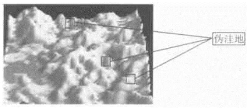
2.2伪洼地去除 8
2.2.1伪洼地的判断 8
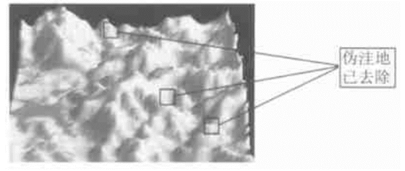
2.2.2去除伪洼地 9
2.3洪水淹没分类 10
2.3.1无源淹没 10
2.3.2有源淹没 11
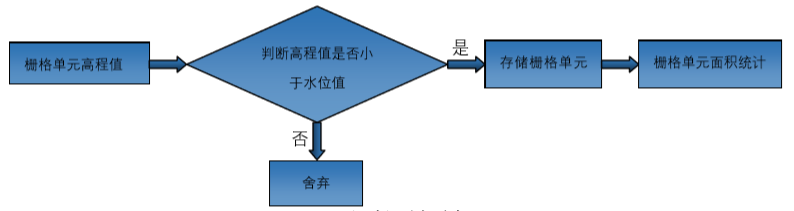
2.4种子蔓延算法 11
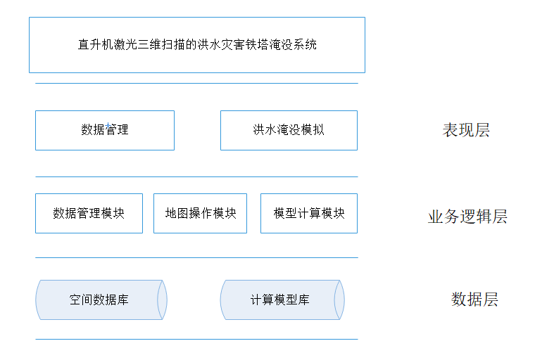
第三章 系统框架设计 14
3.1软件系统设计目标 14
3.2系统框架 14
3.3系统配置 14
3.2.1软件配置 14
3.2.2硬件配置 15
3.4系统开发环境 15
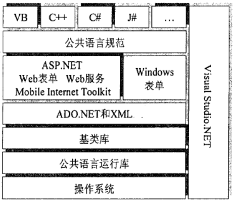
3.4.1微软.NET框架 15
3.4.2 ESRI公司ArcEngine组件 16
3.4.3 GDAL 16
第四章 系统功能实现 18
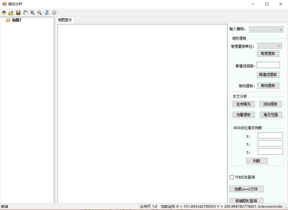
4.1系统主界面 18
4.2地图基本操作模块 19
4.5地形提取模块 19
4.5.1坡度提取 19
4.3.2坡向提取 20
4.3.3等值线提取 20
4.4水文分析模块 21
4.4.1洼地填充 21
4.4.2流向提取 22
4.4.3流量提取 22
4.4.4淹没范围提取 23
4.5点位淹没判断功能 23
4.6加载Excel文件 24
第五章 总结与展望 26
5.1总结 26
5.2展望 26
参考文献 28
致 谢 30
第一章 绪 论
1.1研究背景
洪水灾害是由于江河、湖泊、水库等水位高于正常值,造成水流入境从而对人类社会造成负面影响。在全球范围内,洪水灾害已成为对人类社会最具威胁的数十种非人为灾害中的一种。洪水灾害最直接影响到的就是农业,它会造成农业减产甚至绝产,其次也会对工业造成一定影响。更为严重的是,每次特大洪水灾害发生,都会造成淹没区内的部分民众死亡、失踪。近些年世界经济快速发展,洪灾对人类社会造成的损失有了愈发严重的趋势。由于影响洪水的自然和人为因素众多以及人类对于自然界认识的局限性,就目前而言,还无法完全准确预测出未来很长时间内洪水发生的确切时间和准确地点。所以,人们通常是把洪水灾害当作一个随机事件加以分析和处理。
人类预防洪水的手段一般有两种,第一种是工程方面的方法,也叫防洪工程措施,它的主要手段是通过加固堤坝、疏通河道、洪水分流以及修建水库等方式。通过修建和利用用这些防洪工程,扩大已有河道排泄量、增强河流分流和疏导能力以及水库拦蓄洪水的能力,以达到防洪目的;第二种是非工程方面的方法,也就防洪非工程措施,它的主要手段是指洪水灾害提前预报、洪水灾害时及时警报、管理规划洪泛区、河道淤泥清障、超标准洪水防御措施,以及相关法律和政策等防洪工程措施以外的其他手段。但是由于目前科技和社会发展等方面原因,洪水灾害截至目前仍然是困扰全人类的一大难题。洪水灾害短期内还是难以从根本上防范和彻底消除的。
以上是毕业论文大纲或资料介绍,该课题完整毕业论文、开题报告、任务书、程序设计、图纸设计等资料请添加微信获取,微信号:bysjorg。
相关图片展示: