基于卫星影像的空间数据库更新毕业论文
2020-04-15 20:22:00
摘 要
物体具有位置、形态、大小分布等各方面的信息,对现世界中存在的物体进行定性或定量描述时,我们需要对信息进行系统化管理,由此诞生了数据库技术,为了保证数据库的现势性,需要提高数据库更新频率。
信息时代的数据库更新工作中,数据来源已经不仅仅局限于外业人工采集,航摄影像、空间卫星影像日趋成为重要的空间数据来源。在3S集成技术中,全球定位导航系统为数据库提供了精准的空间数据定位工作,遥感技术为数据库更新提供了最新的影像数据,其中卫星遥感影像矢量化将取代外业全站仪点集采集工作,成为数据库更新技术不可或缺的重要一环。应用遥感技术与卫星影像数据对比数字线划图DLG发现变化要素,在计算机自动解译与人工判读相结合的工作下实现地物要素变化提取、更新。人工目视读取影像弥补了计算机解译工作中对于地物识别的误差,同时对于影像中变化的地物要素的属性内容的更新也需要人工目视解译。这种方法具有准确率高、更新速度快、减小劳动强度等优点,在大中型数据库更新工作中占有重要地位。
本次研究以2009年南京工业大学江浦校区地理数据库为原始待更新数据库,0.8米卫星影像为更新数据源,原始Geodatabase数据库中多种要素已经发生变化,属性等信息需要人工判读影像读取变化。其中江浦校区数据库中需要新建新增要素,在ArcCatalog中进行数据库管理。研究对比了传统数据库更新方式的优缺点,并且对数据库的更新方式进行了讨论,探究数据库更新在GIS系统中所起到的数据支持应用。
关键字:空间数据 数据库 数据库更新 卫星影像 空间数据库 DLG更新
Updating of Spatial Database Based on Satellite Images
Abstract
Objects have information of location, shape, size distribution and so on. When describing the existing objects qualitatively or quantitatively, we need to systematically manage the information. From this, database technology was born. In order to ensure the current situation of database, we need to improve the update frequency of database.
In the database updating work in the information age, the data sources are not limited to manual acquisition in the field. Aerial photography and space satellite images are becoming more and more important spatial data sources. In the 3S integration technology, GPS navigation system provides precise spatial data positioning for database, and remote sensing technology provides the latest image data for database updating. The satellite remote sensing image vectorization will replace the point collection of field total station and become an indispensable part of database updating technology. Using remote sensing technology and satellite image data to compare the DLG of digital line map to find the change elements, the change extraction and updating of ground features elements can be realized under the combination of computer automatic interpretation and manual interpretation. Artificial visual reading of images compensates for the errors of recognition of ground objects in computer interpretation. At the same time, it is necessary to update the attributes of changed ground elements in images by artificial visual interpretation. The method used in this research has high accuracy and fast speed, along with lower labor intensity. Therefore, It is important for large and medium-sized databases updating.
In this study, the geographic database of Jiangpu Campus of Nanjing University of Technology in 2009 was used as the original database to be updated, and the use the 0.8m image to update the database. Various elements in the original Geodatabase database had changed, and the information of attributes needed to be read manually. Among them, the database of Jiangpu Campus needs new and additional elements to be managed in ArcCatalog. This paper compares the advantages and disadvantages of traditional database updating methods, and discusses the updating methods of database, and explores the data support application of database updating in GIS system.
Keywords:Spatial Data; Database; Geodatabase; Update; Satellite Images; DLG update
目 录
摘 要 I
Abstract II
目 录 III
第一章 绪论 1
1.1 研究背景 1
1.2 国内外研究进展 1
1.3 课题研究的内容与技术路线 2
1.3.1研究内容 2
1.3.2技术路线 3
1.4 论文的组织结构 3
第二章 关键技术研究 5
2.1 数据采集技术 5
2.1.1外业人工数据采集 5
2.1.2影像图矢量化 6
2.2 空间数据库管理手段 8
2.2.1Geodatabase 8
2.2.2关系数据模型设计 9
2.2.3 ArcSDE 技术 10
2.3 空间数据库更新 11
2.3.1分层存储、分幅更新 11
2.3.2ArcSDE版本管理更新 11
2.3.3增量更新 12
第三章 数据库设计 13
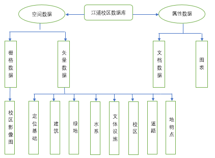
3.1空间数据管理 13
3.1.1南京工业大学更新区域现状 13
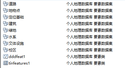
3.1.2数据分类 13
3.1.3分层数据组织 14
3.2数据库优化实施 15
3.2.1数据库优化需求分析 15
3.2.2矢量逻辑设计 15
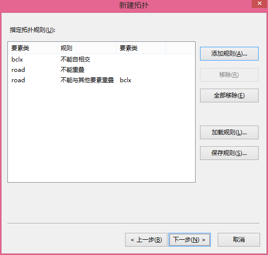
3.2.3拓扑关系建立与检查 16
第四章 空间数据库更新实施 18
4.1 卫星影像预处理 18
4.1.1几何校正 18
4.1.2 图像增强 19
4.2 图像配准 21
4.3 几何数据更新 22
4.3.1面向要素变化区域提取 22
4.3.2面向要素增量更新 24
4.4数据库属性数据更新 28
第五章 结论与展望 30
5.1结论 30
5.2展望 30
参考文献 32
致谢 35
第一章 绪论
1.1 研究背景
在空间数据的知识图谱中,现势性是一个重要概念,数据的现势性是指空间地物随着时间、发展的变化具有的最新属性,能够说明物体的最新情况。随着城市经济建设快速发展,地区地形、地物的变化频繁,原有的地形图、数据库等已不能满足需求,无法准确表达现实情况,由此发展出空间数据库更新技术。空间数据库更新通过各种数据采集手段把最具有现势性的空间数据更新至数据库管理系统,达到满足现势数据库中数据的实时性和准确度。
以上是毕业论文大纲或资料介绍,该课题完整毕业论文、开题报告、任务书、程序设计、图纸设计等资料请添加微信获取,微信号:bysjorg。
相关图片展示: