基于CityEngine的三维城市建模毕业论文
2020-06-20 19:09:07
摘 要
随着近年来国家和政府对各地城市化进程的大力推进,如何建设和发展数字城市(智慧城市)成了很多大中城市迫在眉睫的问题,而三维城市建模作为数字城市中最为基础和重要的部分也越发地受到重视。
传统的手绘作图在当今的信息时代早已落伍,而现在市场上常用的三维建模软件大多是针对单个目标的精细建模,在面对城市中的海量建筑则是显得力不从心,不能满足现在的需求。本文最终选择基于CityEngine的三维城市建模是经过对比市面上的主流建模软件后作出的最终选择,该软件现为ESRA公司产品,与ArcGIS的兼容性是目前的建模软件无法比拟的,除此以外,他也是一款专门为三维城市建模专门设计的软件,对于海量数据尤其是重复度较大的城市片区建筑数据有着独特的处理方法。
本文利用CityEngine建立了部分假想的城市社区模型,并将其与其他三维建模软件进行比较,分析CityEngine与其他软件相比的优势以及劣势。
关键词:数字城市 三维建模 CityEngine
Three dimensional city modeling based on CityEngine
Abstract
With the city all over the country in recent years the urbanization process accelerating, the construction and development of digital city (smart city) into a lot of big city and 3D city modeling as pressing danger, as in the digital city is the basis of the most important part of more and more attention.
Traditional hand drawn drawings have long fallen behind in today's information age,Nowadays, the 3D modeling software used in the market is mostly for the fine modeling of a single object. In the face of the city's massive buildings, it seems powerless, they can't meet the demand now. It is a general trend to introduce the automatic and efficient computer program into the 3D modeling of mass data. The final choice of 3D City Modeling Based on CityEngine is the final choice after comparing the mainstream modeling software on the market, the software is now a ESRA product, and compatibility with ArcGIS is unmatched by current modeling software. In addition, he is also a software specially designed for 3D urban modeling, and has a unique way of dealing with large amounts of data, especially the building data of urban areas with greater repetition.
In this paper, some hypothetical urban community models are built by using CityEngine, and compared with other 3D modeling software. The advantages and disadvantages of CityEngine compared with other software are analyzed.
Key Words: ;Digital city; 3D modeling; CityEngine
目 录
摘要 I
Abstract II
第一章 绪论 4
1.1 研究背景 4
1.1.1 地理信息系统的发展 4
1.1.2 数字地球与数字城市 4
1.1.3 CityEngine的发展 4
1.2 研究的目的和意义 5
1.3 国内外研究现状 5
1.4 论文的组织结构 7
第二章 空间信息的获取 8
2.1 DEM的获取 8
2.2 目标物纹理的获取 8
2.3 建筑物空间数据的获取 9
第三章 城市地物的三维建模 11
3.1地形建模 11
3.2 道路建模 11
3.3 建筑物建模 12
3.4 LOD模型 12
第四章 CityEngine三维城市建模 14
4.1 CityEngine的技术优势 14
4.1.1 CityEngine支持GIS数据且与ArcGIS无缝结合 14
4.1.2 基于规则批量建模 14
4.1.3可视化规则编辑器 15
4.1.4 交互式建模 15
4.1.5 集成Python环境 15
4.1.6 支持多平台操作系统 15
4.2 CityEngine规则(CGA规则) 15
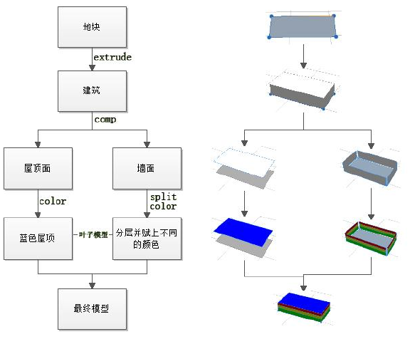
4.2.1拉伸(ectrued) 15
4.2.2分割组件(comp):把整个模型分割成不同的部分 15
4.2.3着色(color) 16
4.2.4切割(split) 16
4.3 CityEngine三维建模 16
4.3.1 建筑物基础建模 16
4.3.2 建筑物贴图 22
4.3.3 建筑物屋顶 23
4.3.4 制作建筑物的LOD模型 26
4.3.4 道路建模 27
4.3.5 地面以及附属物 30
第五章 与市场现有软件的比较 32
5.1 SkatchUp 32
5.2 3ds Max 32
5.3 Skyline 32
第六章 总结与展望 33
6.1 总结 33
6.2 展望 34
参考文献 35
第一章 绪论
1.1 研究背景
1.1.1 地理信息系统的发展
地理信息系统(GIS)是一种特定而又十分重要的的空间信息系统,它是以采集、贮存、管理、分析和描述整个或者部分地球表面(包括大气层在内)和空间和地理分布有关的数据的空间信息系统[1]简而言之就是输入、存储、查询、分析和显示地理数据的计算机信息系统。
自从上世纪60年代地理信息系统的概念在加拿大被提出以来至今,经过四十多年的快速发展,GIS技术已经和GPS(全球定位系统)以及GS(遥感)等空间技术紧密结合,成为了当今研究空间信息的核心手段之一。在GIS越来越深入现在人们生活的今天,随着与各行各业的不断融合,尤其是城市建设不断加强,GIS也派生出了诸如数字地球和数字城市等一系列新兴的概念。
1.1.2 数字地球与数字城市
数字地球,最早由美国副总统戈尔于1998年1月在发表题为“数字地球:认识二十一世纪我们所居住的星球”演说时提出的。数字地球结合了目前测绘科学以及计算机领域的尖端技术,对于现在的社会经济有着巨大的推进作用,伴随着数字地球的深入发展,为了适应城市化进程的推进,一个全新的概念被提了出来:数字城市。
从广义上来讲,数字城市是城市信息化和智能化的结合体,本质是运用技术手段将城市的过去、现在、将来以及宏观和微观都能虚拟化和可视化表现出来,最终为城市规划、应急响应、智能交通等提供固执甚至智能决策[2]。
相关图片展示: