多源遥感数据时空融合模型研究毕业论文
2020-06-19 22:18:57
摘 要
随着遥感技术的高速发展,多个领域都涉及其中,包括农业,林业,渔业,军事,灾害,水文,城市,气象等领域都开展了细致研究和专题应用,总之越来越多的领域都把遥感技术的应用当作重中之重。然而,一种遥感影像存在或时间或空间上的不足,很难满足各行各业的应用需求。高时间分辨率影像在时间上满足需求,但是在空间分辨率上就难以满足一些领域的应用;高空间分辨率影像的空间分辨率很优秀,但是它的获取难度大,获取周期大,在某方面的应用经费也高,面对这些问题,为了利用好两种或者多种遥感影像的时空优势多源遥感融合随之发展而来。本文主要研究的是高分辨率影像landsat8与低分辨率modis_MOD09GA影像的融合问题,使用STARFM 、ESTARFM 、STAVFM三种算法,在崇明岛区域研究多源遥感影像时空融合,得出融合影像,并对融合结果作出定性和定量的质量评价。在融合结果的基础上,计算NDVI植被指数,提取2015年水稻种植面积,做出水稻分布专题图。
关键词:遥感技术 时空融合 融合算法 质量评价 植被指数
Research on Spatial - temporal Fusion Model of
Multi - source Remote Sensing
Abstract
With the rapid development of remote sensing technology, many areas are involved, including agriculture, forestry, fisheries, military, disaster, hydrology, city, meteorological and other fields have carried out meticulous research and special applications, in short, more and more areas are The application of remote sensing technology as a top priority. However, a remote sensing image exists or lack of time or space, it is difficult to meet the needs of all walks of life applications. High spatial resolution images meet the requirements in time, but in space resolution is difficult to meet the application of some areas; high spatial resolution image spatial resolution is excellent, but it is difficult to obtain large, large acquisition cycle, in a The application of funds is also high, in the face of these problems, in order to take advantage of two or more remote sensing image of the advantages and disadvantages of multi-source remote sensing fusion along with the development. In this paper, the fusion of high-resolution image landsat8 and low-resolution modis_MOD09GA images is studied. Using STARFM, ESTARFM and STAVFM, the multi-source remote sensing images are studied in the Chongming Island region, and the fusion images are obtained. The results were qualitatively and quantitatively evaluated for quality.On the basis of the fusion results, the NDVI vegetation index was calculated, and the rice planting area was extracted from 2015 to make the map of rice distribution.
Key Words:Remote Sensing Technology;Time and space fusion;Fusion algorithm;
Quality Evaluation;Vegetation index
目 录
摘 要 I
ABSTRACT II
第一章 绪论 1
1.1 研究背景和研究意义 1
1.2 遥感及融合现状 2
1.3 本文研究内容和思路 2
1.4 论文的组织结构 3
第二章 研究区域及数据处理 5
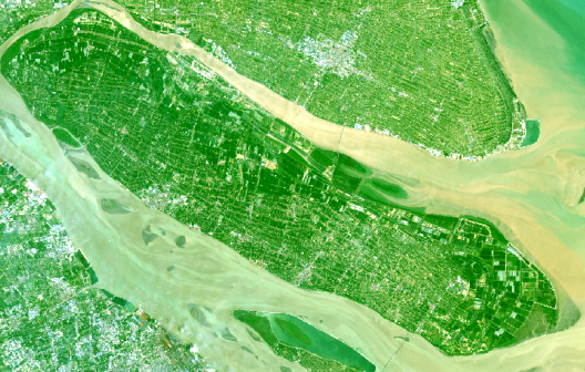
2.1 研究区域概况 5
2.2 数据简介 5
2.3 数据处理 8
2.3.1 数据获取 8
2.3.2 数据处理流程 9
第三章 算法原理 11
3.1 STARFM算法 11
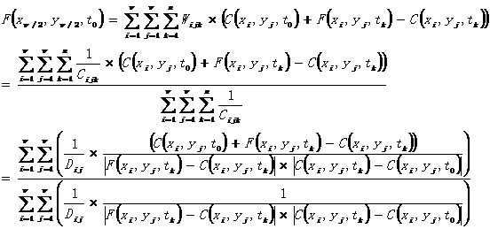
3.2 ESTARFM算法 13
3.3 STAVFM算法 15
第四章 图像融合及质量评价 17
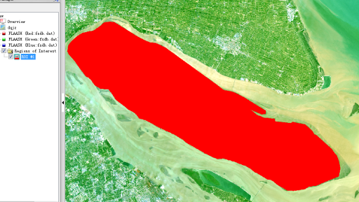
4.1 崇明岛starfm与stavfm算法 17
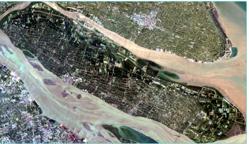
4.1.1 数据融合 17
4.1.2 目视解译 20
4.2 崇明岛内部小范围三种算法研究 20
4.2.1 融合结果 20
4.2.2 质量评价 21
第五章 有关NDVI的应用 25
5.1 基于融合结果计算NDVI 25
5.2 崇明岛水稻面积的提取 26
5.3 制作崇明岛水稻分布图 27
第六章 总结与展望 29
参考文献 31
致谢 33
第一章 绪论
1.1 研究背景和研究意义
遥感获取电磁波信息是遥感器检测远离目标物体和非接触目标物体,通过电磁波敏感获得。与此同时,遥感也是用来获取,确定,处理,分析和应用的探测仪器。遥感图像数据融合是对多个传感器的图像数据进行处理,并且附带其他信息的过程。其着重之处在于可以把复杂多余并且互补的多源数据,用一定的方式处理,从而获得比单个数据更准确和更丰富的信息。生成了新的空间,光谱和时间特点的合成图像[1-2]
为加强研究人员之间的军事交流,美国国防部(JPL联合实验室主任)数据融合工作组成立于1986年,完成了数据融合词典(Lexicon,1991; Kessler,1992)的汇编。在学术领域,数据融合始于20世纪80年代初,但只有相对正式的定义才开始于90年代初。 Mangolini(1994),Hall和Llinas(1997),Pohl和Van,Genderen等(1998)分别给出了不同的数据融合定义。其中,Pohl和Genderen的定义更为典型,他们认为图像融合是将两个或更多图像中的一些算法应用到该技术的新图像中。
相关图片展示: